| Walk grade: | Easy |
| Route type: | Circular |
| Suitable for: | All |
| Terrain: | Coastal paths, flight of steps. Surface varies from hard, firm to smooth and uneven |
| Start: | Langland Bay car park (pay and display) |
| Finish: | Langland Bay car park |
| Distance: | 2 miles |
| Average time: | 1-2 hours |
| Public Transport: | Yes |
| Car parking: | Yes, at Langland Bay (pay and display) |
| Public toilets: | Yes, at Langland Bay |
| Safety Information: | The route crosses the golf course – look out for airborne golf balls! Also, this walking route involves flights of steps. |
The above information is an extract from: Walking for Health, produced by the City and County of Swansea.
If this walk sounds good to you, there’s plenty more information in this handy route map put together by the City & County of Swansea Countryside Access team. Put your best foot forward; download this great little walking route guide and get your walking boots on.
Swansea Council Countryside Access team
# 01792 635746 or 01792 635230
@ countrysideaccess
@swansea.gov.uk
i www.swansea.gov.uk/countrysideaccess
Further links
i swanseabaywithoutacar.co.uk
i www.traveline-cymru.org.uk
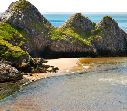
With nearly 400 miles’ worth of rights of way, Swansea Bay offers many memorable walking routes, from short family trips, taking in many of the small churches and landmarks in the area, to routes for the more experienced, with breathtaking views of the Gower Peninsula. Find out more: