fbpx
Sign up to the Admiral Swansea Bay 10k!
Sunday 15 Sep

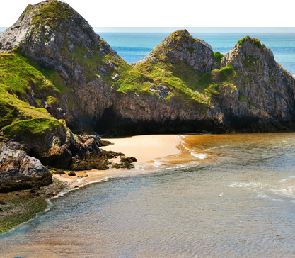
Walk one of the Ramblers’ Association’s ‘Top 10 Coastal Walking Routes’. A scenic, circular walk at the western edge of the Gower Peninsula, chosen by the Ramblers’ Association as one of their ‘Top 10 Coastal Walking Routes’.

Walk Summary

Walk grade: Easy.
Route type: Circular.
Suitable for: All.
Terrain: The walk covers grassy paths, clifftops, field paths and lanes.
Start: Rhossili car park (private parking fee).
Finish: Rhossili car park.
Distance Covered: About 3 miles (4.8km).
Average time: 2-3 hours.

Useful Information

Public Transport: Yes.
Car parking: At Rhossili (private fee).
Refreshments: At the Worm’s Head Hotel just across the car park, and at shop at the top of the car park.
Public toilets: At the bottom of the car park.
Be prepared: Strong shoes or boots and waterproof clothing are advisable.


Safety Information

If you intend to venture out onto the Worm itself, carefully read the notices posted in both the National Trust Visitor Centre and Shop window and the old coastguard lookout hut. These give advice about both tide times and areas best avoided during the bird nesting season. Be sure to contact the coastguard before you embark too.

Walk Details

  1. Leave the car park by the exit at the Worm’s Head end, passing the coastguard cottages and National Trust Visitor Centre and Shop on your left. Pass through a wooden gate onto a broad track making for the Worm, and keeping a stone wall on your left. Keep ahead on this track for about 0.5 mile (0.8km), passing the rather bumpy ground on your right, indicating the presence of an old Iron Age fort. Where the track swings to the left alongside the wall continue ahead along a broad grassy sward as far as the old coastguard lookout hut (now used by the Countryside Council for Wales as a visitor centre).
  2. Here turn left and follow the cliff path for about 0.75 mile (1.2km), as it first skirts around Fall Bay and then continues on to Mewslade Bay, just before the prominent headland of Thurba. The lower path leading down to Fall Bay is no longer officially a footpath, being closed off some years ago, so keep to the upper path alongside the field wall.
  3. At the eastern end of Fall Bay, do not turn left over the iron ladder stile. Instead, keep the wall on your left and follow the cliff path as it swings to the right. Continue along the path around the headland towards Mewslade Bay. Where the path splits take the one to the right to gain the best views of the cliff-top scenery hereabouts. It eventually joins up with the path alongside the wall further along.
  4. Follow the path as it swings to the left above and alongside the Mew Slade. About 50 yards (46 metres) before it rejoins the main path at the wall turn right down a grassy strip to the bottom of the valley. The path is easily identified by a large fig tree about half way down the slope on the right. On joining the path at the bottom, turn left up the valley. Pass through a gate onto a stony track. Continue ahead to emerge at Pitton Farm, through a second gate.
  5. Turn left, passing some cottages on your left, to emerge at the main road to Rhossili. Cross the road to the lane by the post box, ahead and slightly to the right. Continue up the lane to the point where it splits into two tracks. Take the left track (indicated by a waymark arrow on the telegraph pole) and ascend gently. Pass a bungalow on your left, followed by a house on your right. About 50 yards (46 metres) past the house cross over a stile on the left, indicated by a waymark arrow, and a ‘Glamorgan Naturalists Trust – Nature Reserve’ sign (a body now more correctly known as the Glamorgan Wildlife Trust). The path here is a little overgrown, but never in doubt. Pass an old thatched cottage on your left, and leave the reserve over a stile. Turn half right to join an old overgrown brick driveway. Continue to a stile to the right of a gate. Cross the stile into a lane and aim for the track directly in front of you.
  6. Follow the track to a Welsh Water reservoir. Immediately past the reservoir turn left and aim for the white house ahead, and slightly to the left. Just past the house, pick up a stone wall (not literally) and follow it, keeping it on your left and staying on the common. Do not cross a waymarked stile over the wall but stay on the common, and keep to the right of it. Where it turns sharp left, above Rhossili, continue ahead for about 20 yards (18 metres) to join the wide and grassy path coming off Rhossili Down. Turn left, downhill, onto the lane to join the main road through Rhossili. Turn right and return to the car park, either via St Mary’s Church, or down the road.


Highlights

  • Half way along the cliff walk between Rhossili and the old coastguard lookout station, you will notice some rather lumpy ground to your right. This is all that remains of an old iron-age fort, known as Old Castle. Ravaged both by time and the activities of the local quarrymen, it is now only discernible as a series of humps and trenches.
  • On the opposite side of the track, and over the stone wall, is ‘The Viel’, (or ‘The Vile’), this being old Gower dialect for a field. The Viel is one of the few remaining examples of the medieval open field strip system. The idea was that the local farmers would have strips of land allocated to them from different areas to ensure all had their fair share of the ‘good’ and the ‘not so good’ quality land.
  • Just along from here and below the old coastguard lookout is the rather curiously and quaintly named Kitchen Corner. The wooden hut at the bottom of the cliffs was built by a Swansea fisherman, by the name of Mr. Coonan, to allow him to fish for bass off the cliff edge, as well as launch his boat. A path leads safely down to it, should you wish to explore at closer quarters.
  • The ‘Worm’s Head’ is a fantastic promontory divided into three clear and distinct sections; the Inner, Middle and Outer Heads, very similar in profile to a serpent. Accessible only around low tide, it is owned by the National Trust and is a haven for sea birds, such as kittiwakes, guillemots, razorbills, and gulls of different types. If you intend to venture across to the Worm, make a careful note of tide times displayed at the National Trust shop at Rhossili and be sure to contact the coastguard before you set off.
  • Mewslade Bay is one of those beaches, along with Fall Bay just before it, that completely disappears at high tide. It is a popular and safe bathing beach. The origin of the name is uncertain but is popularly believed to be derived from the old word ‘Mew’ , meaning a seagull. The dramatic limestone cliffs hereabouts make this a favourite spot for rock climbers. They are also home to colonies of seabirds, in particular, kittiwakes who have bred very successfully here since the 1940’s. The word ‘slade’ seems to mean a dry grassy valley running down to the sea, usually cloaked in gorse, or furze.
  • Middleton is the birthplace of Petty Officer Edgar Evans of Scott’s ill-fated Antarctic expedition. His poignant memorial is to be seen inside Rhossili church. Middleton was also home to some of the infamous smugglers of Gower, although to walk through it now, you might never think so. Back in the last century the village boasted three inns, including The Ship Inn (now Ship Cottage). It is said they all had more than one cellar too!

The above information is an extract from: Circular Walks in Gower by Nick Jenkins.

More Information

Swansea Council Countryside Access team
# 01792 635746 or 01792 635230
@ countrysideaccess@swansea.gov.uk
i www.swansea.gov.uk/countrysideaccess

Further links
i www.baytrans.org.uk
i www.traveline-cymru.org.uk

With nearly 400 miles’ worth of rights of way, Swansea Bay offers many memorable walking routes, from short family trips, taking in many of the small churches and landmarks in the area, to routes for the more experienced, with breathtaking views of the Gower Peninsula. Find out more: